Remote Building Inspection for Insurance Assessment
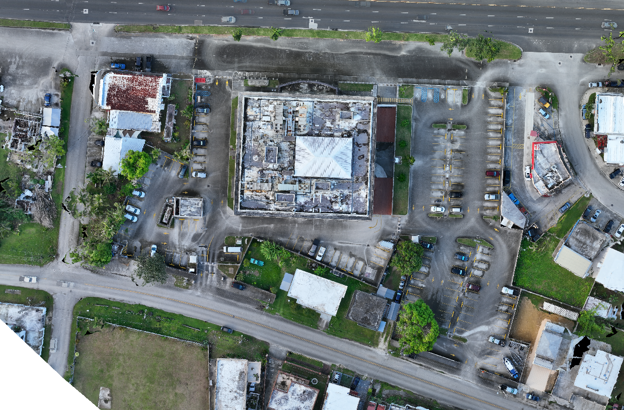
High resolution Orthomosaic Mapping
.png)
Client
Ripple Industries & Insurance Providers
Project Type
Orthomosaic Mapping & Remote Inspection
Location
Various, Guam
Project Overview
To support insurance assessments and building inspections, 2cofly conducted high-resolution aerial surveys of six different sites, producing sub 1” GSD orthomosaic maps. These highly detailed, georeferenced maps provided insurers with accurate, up-to-date site documentation, allowing them to assess structural conditions, detect damages, and verify property details remotely—without requiring costly on-site inspections.
Using drone-based orthomosaic mapping, 2cofly delivered clear, distortion-free, and measurable aerial data, enabling insurance providers to make informed policy decisions, process claims faster, and reduce on-site assessment costs.
The Challenge
Traditional insurance inspections rely on manual site visits and low-resolution satellite imagery, both of which pose significant limitations:
Satellite imagery (e.g., Google Maps) is often outdated, showing properties as they existed months or even years ago.
Manual site inspections require extensive fieldwork, increasing costs and project timelines.
Low-resolution images fail to capture fine details, making it difficult to assess damage or structural integrity accurately.
To address these challenges, 2cofly utilized high-resolution drone mapping, providing precise, current, and measurable data that insurers could analyze remotely with confidence.
Approach & Methodology
High-Resolution Orthomosaic Mapping
✔ Sub 1” GSD Imaging – Captured ultra-high-resolution aerial images, ensuring clear visibility of roofing, walls, surrounding property, and infrastructure.
✔ Georeferenced Orthomosaic Maps – Created distortion-free, true-to-scale maps for accurate remote assessment and measurement.
Drone-Based Efficiency
✔ Rapid Data Collection – Surveyed all six sites quickly and efficiently, reducing on-site inspection costs.
✔ Detailed, On-Demand Insights – Provided insurers with real-time property conditions, eliminating reliance on outdated satellite imagery.
Deliverables Provided
✔ High-Resolution Orthomosaic Maps – Current, georeferenced aerial imagery for site analysis.
✔ Measurable Property Data – Precise building dimensions, structural details, and surrounding terrain.
✔ Remote Inspection Capability – High-detail imagery allowed insurers to assess properties without needing on-site visits.
Why an Orthomosaic Map Instead of Google Maps?
✔ Up-to-Date vs. Outdated Imagery – Google Maps often shows months-old or years-old satellite images, while drone-based orthomosaics capture real-time conditions for accurate assessments.
✔ Higher Resolution & Detail – Google Maps’ satellite images have limited resolution, making it difficult to inspect roofing, cracks, water damage, or structural issues. Our orthomosaic maps provide sub 1” GSD clarity, allowing insurers to see fine details with extreme accuracy.
✔ Georeferenced & Measurable – Google Maps is not survey-grade and lacks the accuracy required for precise measurements. Orthomosaic maps are spatially corrected, meaning distances, areas, and damage extent can be measured with precision.
✔ Distortion-Free & True-to-Scale – Unlike aerial photos taken at an angle, orthomosaic maps are corrected for camera tilt and terrain variations, ensuring that every part of the image is perfectly scaled and distortion-free.
Results & Project Impact
Faster & More Efficient Insurance Assessments
By using high-resolution drone mapping, insurance providers could review property conditions remotely, significantly reducing the need for field inspections and expediting policy approvals and claims processing.
Improved Damage Detection & Documentation
The detailed aerial imagery allowed insurers to identify damage, assess risk, and verify claims with higher accuracy than traditional inspection methods.
Cost-Effective & Scalable Solution
Drone-based remote inspections provided a cost-efficient alternative to manual property assessments, allowing insurers to analyze multiple sites quickly without extensive labor costs.
Conclusion
This project highlights the growing role of drone-based orthomosaic mapping in insurance and property assessments. By providing high-resolution, up-to-date, and measurable aerial data, 2cofly helped streamline insurance inspections, allowing for faster, more accurate, and more cost-effective risk assessments.
For insurance providers, property managers, and real estate developers looking for cutting-edge remote inspection solutions, 2cofly delivers industry-leading drone mapping services that optimize efficiency, accuracy, and decision-making.

2cofly (pronounced Ecofly) is Micronesia's leading drone service and education provider. Our core competency lies in remote sensing via various sensing technologies such as photogrammetry, LiDAR, thermal and more.
Few key deliverables we can output with our drones & sensors:
Orthomosaic Mapping (+ Planimetric Mapping)
Topographic Mapping (via LiDAR & photogrammetry)
General LiDAR Mapping (land feasibility study, power line, etc)
Aerial Inspection
Aerial Magnetometry (underground metal detection)
Thermal Map (radiometric)
We are also the largest drone training and education provider, offering:
Online Course
In-person workshops
Custom curriculums for students and professionals
Schedule a free consultation
(671) 988-1532 | dwl@2cofly.com

_gold-black.png)


